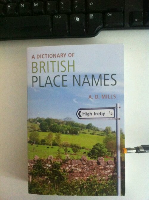
I was given a present this Christmas and here it is:

It was a bit unusual in that it came with a veiled challenge (written inside) – to maybe include some of the info in a blog about it. Well I thought for a bit about how you could do that. It would be tricky if it’s not going to be boring. It’s a dictionary, it lists 17,000 place names and how they came about.
It is, though, printed in what has to be the tiniest font EVER! I’ve never had a book with such tiny print. I was intrigued so I counted. Each page can fit 52 lines without headings. I counted an ordinary book – 34/35 lines. That means 50% more lines per page. I also counted the words (just one page in each book as a random sample): the ordinary book had 351, the introduction to the place name dictionary had 711 so just over twice as many words per page! I also measured the area of the text on the page and the dictionary is approximately 1cm bigger on the length and on the width although the outside dimensions of the dictionary are smaller than the one I compared it with. So the ‘tiny-font’ dictionary has only a slightly larger area of text but twice as many words. The intro tells me it has the most up-to-date info on the very latest place name research by the best guys in the field. What is surprising is the number of ways places get their names: sometimes from the age of the place so the name might have a Latin or Saxon origin depending on whether Romans or Saxons were there first; sometimes from the type of landscape where they’re located; sometimes from the name of a person or people originally involved in its founding and so on – that’s toponymy. So, as I’m wondering what to write about, a few ideas came to mind:
Idea no.1 - I could work my way through it doing, say, 10 entries at a time. As there are 17,000 entries, that all appear in the Ordnance Survey Atlas of the UK, there would be enough stuff for 1,700 blogs and at one a week that’s……oh just over 32 years! However I guess readers would get fed up with that very quickly. Idea 1 rejected.
Idea no.2 – pick a random sample say one from each letter of the alphabet so 26 entries. Nah! Too many. Idea 2 rejected.
Idea no.3 – what about something on places which have something unusual about them in terms of their geography? How about starting with 4 significant ones? – The places which are the furthest north, south, east & west, on the mainland of Great Britain. Now if you’re like me you probably don’t know all of them. That became my starting point – to find out where they are.
1. Let’s start at the top, at the northernmost point. Most folks think it’s John o’Groats as it’s the start point for all sorts of people who do what is called the “End-to-end” journey (to Land’s End – about 874 miles) often for charity: walkers, runners, cyclists, wheelchair, skateboard & assorted other journeys. Although there’s not much detail in the dictionary I was curious about how the name came about. It seems it comes from a Dutchman, Jan de Groote. He built a house up there and started running a ferry to the Orkney Islands in about 1496 – the fee four (old) pence so equivalent to about 1½p in today’s money. Four old pence was known as a groat in English and some suggest that the Dutchman’s fee is the actual origin of the John o’Groats name.
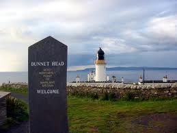
However in terms of latitude John o’Groats isn’t the actual furthest point north. That honour belongs to Dunnet Head: the actual latitude north figures are 58.67⁰N for Dunnet Head & 58.64⁰N for John o’Groats. And in case you had any doubts they’ve cast it in stone and here it is:

The dictionary doesn’t have it explained separately. The place is not inhabited and is roughly half way between John o’Groats & Thurso to the west, and is a promontory on the northern coast of Scotland. Its name comes under the explanation for the Thurso entry. Thurso, it says, comes from a river of the same name and it prob means ‘bull river’. That name comes from the old name of Dunnet Head which was known by the Romans asTarvedunum which means ‘bull fort’. I know the Romans built Hadrian’s Wall separating Scotland from England but I didn’t know they’d actually gone right to the top.
2. Next is the furthest SOUTH. Once again it’s not where you think it is. Most people believe Land’s End is the most southerly but in fact it’s a place called The Lizard. If you want the detail: Land’s End sits at 50.06⁰N and Lizard Point is at 49.95⁰N so it’s basically one tenth of one degree further south. Here’s the National Trust sign. (The National Trust sign http://www.flickr.com/photos/12651139@N05/7467620124/
down there specifies latitude 49⁰ 57’ but as there are 60’ in one degree, 57’ = 0.95 degrees which explains the 49.95⁰, in case you were wondering……..probably not.)
There doesn’t seem to be one of those stone or metal signs for the most southerly point so, apart from the NT sign above, this one will have to do:
http://www.flickr.com/photos/fray_bentos/173694200/in/photostream/
You can just about see Lizard Point underneath the Gifts & Souvenirs on the shop front.
3. Next is EAST. I had no idea on this one. Research tells me it’s an area of Lowestoft called Lowestoft Ness and the local council have put a notice there:

The town’s name derives from an earlier version in the Domesday Book, Lothu Wistoft. It means: “Homestead of a man called Hlothvér”. The ‘toft’ part of the name means homestead but I know what you’re thinking: who was this Hlothvér guy? Well it’s possible it might have been someone of the same name who appears in an old Swedish poem called The Lay of Volundor maybe someone named after him. Volundwas an artisan also known as Wayland the Smith and Prince of the Elves and here’s the beginning of that poem:
1. Three maidens flew through Myrkvith from Southland,
young valkyries*, in wars to try them;
they sate by the lake, their limbs to rest,
fair southron maids, precious flax spinning;
2. (11) Hlathguth and Hervor, Hlothvér's daughters,
and wise Olrún, Kíar's offspring.
Did one of them wind her white arms
about Egil, to her bosom held him;
3. (and Hlathguth fair, enfolded Slagfith); (12)
............ ................... ............... .................
but Hervor, the third of these sisters,
winded her arms 'round Volund's neck.
4. Thus dwelled the sisters seven winters,
but on the eighth ay in yearning,
but on the ninth they needs must part:
longed the maidens through Myrkvith to fly,
the young valkyries*, in wars to try them.
*The Valkyries, from Norse mythology, were female figures who chose which soldiers died in battle and which lived.
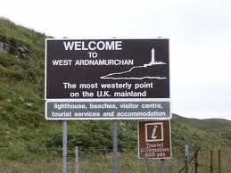
4. And finally the furthest point WEST: Slight confusion here. Look at the pic below

And then read this entry on the Undiscovered Scotland website:
“And mainland Great Britain's westernmost point? Anyone suggesting it's somewhere in Cornwall is well wide of the mark. It is actually a rocky outcrop called Corrachadh Mòr, some three quarters of a mile south (and some 30-50 yards further west, depending on how you measure it) of Ardnamurchan Point,…….”
Looking at the map I can only assume AP gets all the visitors is because of access. If you look at Corrachadh Mòr on a map there don’t appear to be any roads or paths leading to it. Ardnamurchan has a road, a visitor centre and other stuff. Not surprisingly then no entry for Corrachadh Mòr in the dictionary so will have to make do with the one for Ardnamurchan. (It is after all only about 15 metres short of being the most westerly point.) In the 8th century it was known as Art Muirchol and then Ardnamurchin in the 14th and it means ‘Point of the Otters’ (or sea-dogs). In the first version the ‘chol’ ending means ‘sin’ possibly implying that there was piracy around there.
Btw, websites suggesting that Land’s End is furthest point west (eg. http://www.sterlingtimes.org/memorable_images38.htm) should be disregarded. The longitude values are Land’s End 5.71⁰W and Ardnamurchan Point 5.98⁰W)
Anyway, fancy building a house at Corrachadh Mòr to claim the westernmost title then?
And to finish how about this? In 1995 there was even one guy who cycled from John o’Groats to Land’s End via the west, east & south extremities (Ardnamurchan Point, Lowestoft Ness & Lizard Point) clocking up a total of 1568 miles instead of the usual 874 for the direct route.
Have any of you been to any of these Mainland extremities?
And there you have it, my first attempt from the dictionary of British place names.
No comments:
Post a Comment